Showing 5616 items matching somers street
-
 Whitehorse Historical Society Inc.
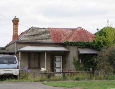
Newspaper - Article, 28 Somers Street, Mitcham, 31/08/1996
... 28 Somers Street, Mitcham...Somers Street...Auction of 28 Somers Street, Mitcham on 7 September 1996... Mitcham melbourne Article Newspaper 28 Somers Street, Mitcham ...Auction of 28 Somers Street, Mitcham on 7 September 1996. Alistair Knox, architect, owners, Joan and Noel Burleysomers street, mitcham, knox, alistair, burley, joan, burley, noel, auctions -
Whitehorse Historical Society Inc.
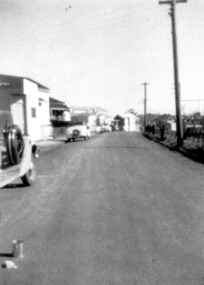
Map, Burwood Road, Box Hill City, 1952
... somers street... central avenue burwood scott grove somers street gilmour street ...Country Roads Board survey of Burwood Road, Burwood between Central Avenue and Elgar Road. Includes details of fencing, nature of buildings. With penciled additions to 1957.Country Roads Board survey of Burwood Road, Burwood between Central Avenue and Elgar Road. Includes details of fencing, nature of buildings. With penciled additions to 1957.Country Roads Board survey of Burwood Road, Burwood between Central Avenue and Elgar Road. Includes details of fencing, nature of buildings. With penciled additions to 1957.maps, burwood road, burwood, parer street, elgar road, cromwell street, ireland street, central avenue burwood, scott grove, somers street, gilmour street, evans street, edwards street, mills road -
 City of Moorabbin Historical Society (Operating the Box Cottage Museum)
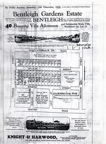
Flyer - Bentleigh Gardens Estate, Bentleigh, 1926
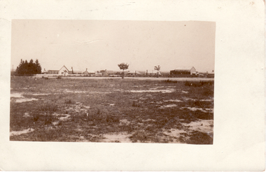
... Somers Street... of Moorabbin Huntly Road (now Gawla st) McLean Avenue Somers Street ...The train line from the city to Frankston was electrified in 1922 which intensified the sale in the municipality of Moorabbin, particularly land which was in the vicinity of the railway stations.Example of the progress of the Municipality of MoorabbinPhotocopy of advertising flyer for auction of real estate sales - plan of building blocks for saleBentleigh Gardens Estate, Bentleigh - 40 housing allotments - Auction Saturday 13 November 1926huntly road (now gawla st), mclean avenue, somers street, thomas street, bentleigh, real estate, auction -
Whitehorse Historical Society Inc.
Document, Notice of motion, 1932
... Somers Street... Tennyson Street Mitcham Lucknow Street Mitcham Somers Street ...Notice of motion from councillor R.A. Plant to Shire of Blackburn and Mitcham re alterations of street names, 15 Mar 1932.Notice of motion from councillor R.A. Plant to Shire of Blackburn and Mitcham re alterations of street names, 15 Mar 1932.Notice of motion from councillor R.A. Plant to Shire of Blackburn and Mitcham re alterations of street names, 15 Mar 1932.street names, shire of blackburn and mitcham, plant, r.a., lawson street, blackburn, musk street, blackburn, hartigan street, blackburn, milton street, nunawading, brunswick road, mitcham, peel street, mitcham, tennyson street, mitcham, lucknow street, mitcham, somers street, mitcham, victory street, mitcham -
 Greensborough Historical Society
Aerial Photograph, Greenhills Aerial View, 1945_
... Photocopy of part of 1945 aerial survey. Some streets have... View Photocopy of part of 1945 aerial survey. Some streets have ...Section from the 1945 aerial survey of Greensborough, including part of Diamond Creek Road, Greenhill Road, Crest Street and Albion Crescent.Photocopy of part of 1945 aerial survey. Some streets have been marked.greenhills -
Whitehorse Historical Society Inc.
Article, Readers all over the place, 2001
... , Nunawading, including photo of sign for Somers Street...., including photo of sign for Somers Street. street signs art craft ...Article on street sign construction by Art Craft, Nunawading, including photo of sign for Somers Street.Article on street sign construction by Art Craft, Nunawading, including photo of sign for Somers Street.Article on street sign construction by Art Craft, Nunawading, including photo of sign for Somers Street.street signs, art craft, nunawading, patterson, matt, naccari, adrian, holden, lela -
Whitehorse Historical Society Inc.
Map, Subdivision Plan for part of Blackburn Park, c1910
... Station Street and Alfred Street. Some purchasers noted between... Station Street and Alfred Street. Some purchasers noted between... Station Street and Alfred Street. Some purchasers noted between ...Photocopy of advertisement for sale of subdivision of area in BlackburnPhotocopy of advertisement for sale of subdivision of area in Blackburn between the railway line and Whitehorse Road between Station Street and Alfred Street. Some purchasers noted between 1903 - 1912.Photocopy of advertisement for sale of subdivision of area in Blackburnland subdivision, whitehorse road, blackburn, station street, blackburn, railway road, blackburn, queen street, blackburn, albert street, blackburn, chapel street, blackburn, george street, blackburn, cottage street, blackburn, alfred street, blackburn -
Whitehorse Historical Society Inc.
Book, The Origins of Box Hill street names, 1985
... A listing of some of the streets of Box Hill... A listing of some of the streets of Box Hill with explanations ...A listing of some of the streets of Box Hill with explanations as to their known or likely origins.A listing of some of the streets of Box Hill with explanations as to their known or likely origins.A listing of some of the streets of Box Hill with explanations as to their known or likely origins.box hill, street names -
 Greensborough Historical Society
Map, Green's subdivision of Greensborough, 1860c
... by Edward Bernard Green. Some street names are different to today. ... subdivision of Greensborough by Edward Bernard Green. Some street ...This map shows the original subdivision of Greensborough by Edward Bernard Green. Some street names are different to today. This map shows the plan on which the town of Greensborough was based.Copy of early map showing subdivision of Greensborough. Black ink on white paper.edward bernard green, greensborough -
 Greensborough Historical Society
Aerial Photograph, Greensborough aerial with property overlay, 1945_
... of central Greensborough, with property overlay boundaries and some...Street names and some property numbers. Overlays by Noel... with property overlay markings Street names and some property numbers ...Enlargements of section of 1945 aerial survey photographs of central Greensborough, with property overlay boundaries and some street numbers by Noel WithersTwo photocopied enlargements with property overlay markingsStreet names and some property numbers. Overlays by Noel Withers.greensborough, plenty river -
 Stawell Historical Society Inc
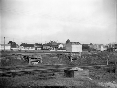
Photograph, Railway Yards with loading ramps and weatherboard shed c1960
... Virtually the same view, but shows some more Wakeham Street... and weatherboard shed c1960 Virtually the same view, but shows some more ...Railway Yards Stawell with loading ramps and weatherboard shed. Showing Wakeham Street Houses in background c1960Virtually the same view, but shows some more Wakeham Street houses. c 1960's. stawell railways transport -
 Surrey Hills Historical Society Collection
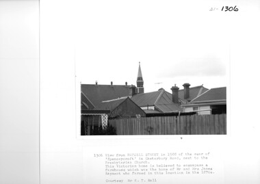
Photograph, View from Russell Street, of the rear 'Spencecroft' in 1988
... A black and white photograph of the rear of some buildings... photograph of the rear of some buildings from Russell Street ...Spenceycroft was home of James and Elizabeth Rayment, who had a dairy farm in the area in the 1870s. The house was located in Canterbury Road next to the Surrey Hills Presbyterian Church. For many years, it was hidden behind a large fence sheltering it from the noise of traffic along Canterbury Road. It has been claimed that it incorporated part of the original farmhouse built on the site by George Klepper, who planted a vineyard in the area. George’s family was one of a number of German families who settled in Surrey Hills during the later part of the 19th century. In recent years Spenceycroft was sold several times and became increasingly derelict. Since its last sale, it has been demolished. Some of the above may be in error. Research is currently being undertaken to authenticate claims previously asserted.A black and white photograph of the rear of some buildings from Russell Street, at the rear of 'Spencecroft'.house names, spenceycroft, spencecroft, russell street, surrey hills, james rayment, (mrs) elizabeth rayment -
Whitehorse Historical Society Inc.
Article, Painful memories linger on
... in the war, and after whom some Mitcham streets have been named..., and after whom some Mitcham streets have been named, [note: errors ...Anzac Day feature on Raleigh Armstrong, returned World War 2 serviceman and on five Mitcham servicemen who died in the war, and after whom some Mitcham streets have been named, [note: errors in the article corrected] by Salena Brunsdenarmstrong, raleigh edward, till, alwyn, loftus, owen spencer, bremner, william ross, peake, ronald mosely, vasey, george, young, joseph leopold, alwyn street, mitcham, owen street, mitcham, ross street, mitcham, ronald street, mitcham, vasey grove, mitcham, young street, mitcham, mcphee, peter -
 Melbourne Tram Museum
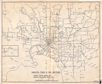
Map, Melbourne & Metropolitan Tramways Board (MMTB), "MMTB Tram and Bus Sections", mid 1960's?
... lines, station, some cross streets. Scale 1"=1 Mile.... Ormond shown as bus. Shows railway lines, station, some cross ...Map - photocopy - titled "MMTB Tram and Bus Sections" showing tram tracks and bus routes, drawing No. P13842, c mid 1960's, Footscray and Point Ormond shown as bus. Shows railway lines, station, some cross streets. Scale 1"=1 Mile.trams, tramways, map, buses, melbourne, footscray -
 Ringwood and District Historical Society
Photograph, Entrance to Ringwood Railway Station - 1939
... Black and white photograph taken from street. Some shops... street. Some shops in middle-ground with some men standing ...Black and white photograph taken from street. Some shops in middle-ground with some men standing on footpath and road. Brick building (station) in background with cars parked in front.Typed below photograph, "Entrance to Ringwood Railway Station - 1939". -
 Surrey Hills Historical Society Collection
Photograph, Stirling Crescent Surrey Hills in 1930s, 1930s
... A black and white photograph of a street with some houses... in 1930s A black and white photograph of a street with some houses ...Paddy Slavin had a bakery at 118 Union Road, which had a rear exit onto Stirling Crescent. On the left is part of Paddy Slavin’s Bakery at 118 Union Road. The house with the hedge was that of Ada McBeath, organist for many years at the Presbyterian and the Wycliff Churches who lived at No.16 from 1900-1940. Phillip and Winifred Slavin are still listed in electoral roll in 1963 but by 1968 had moved to Gipps Street Collingwood, where he was still employed as a pastrycook. A black and white photograph of a street with some houses and cars on the left and electricity poles and the railway line on the right hand side.stirling crescent, surrey hills, bakery, streetscape, (mr) paddy slavin, (ms) ada mcbeath, churches, presbyterian church, wycliff church, organist, (mr) phillip slavin, (mrs) winifred slavin, streetscape, pastrycook -
 Victorian Interpretive Projects Inc.
Photograph - colour, Clare Gervasoni, House with shingle roof in Lydiard (North) Street, Ballarat, 2014, 18/01/2015
... (North) Street Ballarat. Some of the iron roofing has been... weatherboard house in Lydiard (North) Street Ballarat. Some of the iron ...Although this house has been clad and had an iron roof put onto it, the historical integrity still appears to be intact. Colour photograph of a clad weatherboard house in Lydiard (North) Street Ballarat. Some of the iron roofing has been removed exposing shingles.weatherboard, shingles, lydiard street, house -
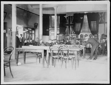 Mission to Seafarers Victoria
Photograph - Photograph, Sepia, c. 1910
... institute, Siddeley Street. Some are reading, the man standing... of the Missions to seamen institute, Siddeley Street. Some are reading ...Men resting in the main hall of the Missions to seamen institute, Siddeley Street. Some are reading, the man standing is playing bagatelle, a form of pool game. On the left side at the back is the boot with sign saying: Sailors' lettersIn pencil: 137seaman, siddeley street institute, main hall, letters, bentwood chairs, post office, bagatelle, pool, billiard, games, sailors -
 Port Melbourne Historical & Preservation Society
Photograph - Harper's factory buildings, Beach and Rouse Streets, Port Melbourne. Awaiting redevelopment, 1980s
... (colour photo). c 1980s External view on Beach street of some... (colour photo). c 1980s External view on Beach street of some ...Harper factory buildings on Beach and Rouse Streets (colour photo). c 1980s External view on Beach street of some of the buildings awaiting redevelopment. built environment, built environment - commercial, harper's, redevelopment -
 Federation University Historical Collection
Photograph - Photograph - Colour, Ballarat School of Mines M.B. John Building
... . John Building on Albert Street, Ballarat. Some images show.... John Building on Albert Street, Ballarat. Some images show ...On 11 June 1987 The M.B. John Trade–Art building (Albert Street front) of SMB was officially opened by the Hon. John Cain, Premier of Victoria, in the presence of Morgan B. John. Programs include 3 Dimensional Art, Painting & Decorating, and Engineering Trades. (SMB Institutional Plan 1989)Colour photographs of the Ballarat School of Mines M.B. John Building on Albert Street, Ballarat. Some images show the Ballarat School of Mines Botanical Garden.ballarat school of mines botanical garden, m.b. john building, ballarat school of mines, morgan b. john, m.b. john, morgan bevan john, trades -
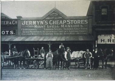 City of Ballarat Libraries
Photograph - Card Box Photographs, Jermyn's Cheap Stores, Ballarat circa 1920
... The store was located on Mair Street. Some of the men... Street. Some of the men pictured are Frank Scully?, Albert Glover ...The store was located on Mair Street. Some of the men pictured are Frank Scully?, Albert Glover, Stan Rowsel, David Pratt, Mick Duggan and Bill Hawker.jermyn's cheap store, frank scully, albert glover, stan rowsel, david pratt, mick duggan, bill hawker, commerical, work, vehicle, building -
 Surrey Hills Historical Society Collection
Photograph, Back Creek (later South Surrey Park), c 1936, 1936
... Street. Some of their backyards face onto the open space along... Street. Some of their backyards face onto the open space along ...This photo was taken at the opening of the footbridge by Sir Winston Dugan in 1936.South Surrey Park was developed on land which had been the property of the Kleinert family. Their land extended from Union Road to Essex Road. They ran horses, ducks and fowls and Emily Kleinert grew flowers. Alan Holt research: Lot 6 was sold to Martin Klienert by Karl Richter in 1860 together with a portion of another adjacent lot. From 1860-1885 Martin worked it as a market garden leasing some land for grazing when it was not required for gardening. He died in 1898. In a formal document, William declared he was the son of Martin "who purchased land in 1860, died in 1898 and the land has been continually occupied by father and family since. It has been cultivated as a market garden; when not being used for gardening it was let for cultivation and grazing." William died in 1939 and the property passed to his sons Martin and Ernest. The family sold the land to the Camberwell Council in the 1950s.This photo is significant as it shows the transition from rural to urban land use in Surrey Hills.Black and white photo taken in the area later known as South Surrey Park. Back Creek is in the foreground. There is a tent on the LHS and approximately 7 houses which front Verdun Street. Some of their backyards face onto the open space along the creek bed.parks and reserves, creeks, south surrey park, civic occasion, official events, back creek, verdun street, 1936, kleinert family, sir winston dugan, topography -
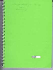 Greensborough Historical Society
Book, Greensborough streets and their residents / compiled by Faye Fort (nee Partington), 2012_
... This is an incomplete list of families who resided in some... who resided in some central Greensborough streets. Compiled ...This is an incomplete list of families who resided in some central Greensborough streets. Compiled by Faye Fort (nee Partington) from her own memory assisted by various members of Greensborough Historical Society. This is a work in progress.Compiles a list of Greensborough residents according to the street in which they lived.Spiral bound notebook, bright green cover. handwritten pages. Incomplete. Handwritten pages throughout.greensborough streets, faye fort (nee partington) -
 Whitehorse Historical Society Inc.
Postcard, Christ Church, Mitcham (Anglican), C.1911
... , Mitcham (Anglican) Corner Whitehorse and Edward Street, and some..., Mitcham (Anglican) Corner Whitehorse and Edward Street, and some ...Black and white photo (three copies) of Christ Church, Mitcham (Anglican) Corner Whitehorse and Edward Street, and some of the homes in Edward Street. Also shown is the Guides Hall (also used by Scouts) in Brittania Street..christ church anglican church mitcham, edward street, mitcham, mitcham guide hall, mitcham scout hall -
 Warrnambool and District Historical Society Inc.
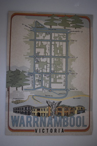
Document, Ella Webb, Warrnambool artist, Street Walks of Warrnambool, 2018
... and the other side has a sketch map of some of the main streets... of the main streets of Warrnambool and some of its attractions ...This is a tourist guide to Warrnambool produced by a local artist, Ella Webb, in conjunction with the Warrnambool and District Historical Society. It includes a sketch map showing the location of some points of interest – buildings and sites of historical interest, places of interest that are no longer existing, some natural features (mainly along the coast) and some information about incidents and people in the past. It is an attractive broadsheet that is a useful guide for visitors to Warrnambool. This sheet is of interest as a modern-day tourist map produced in an artistic fashion by a local Warrnambool artist.This is a single sheet of thick paper printed on both sides in green, brown, yellow and beige tonings. One side of the sheet has sketches of buildings and places of interest and printing and the other side has a sketch map of some of the main streets of Warrnambool and some of its attractions. -
 Warrnambool and District Historical Society Inc.
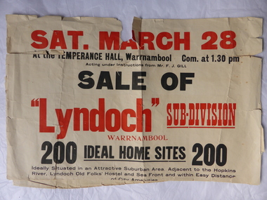
Poster, Lyndoch Sub-Division
... and the edges are torn and, in some sections, missing. The streets map... sections, missing. The streets map has some pencil annotations ...This is a poster advertising the sale of the Lyndoch sub-division in Warrnambool with the sale of 200 housing sites. The sale took place about 1958 with the land sold by Frederick Gill, a Warrnambool jeweller. The land was previously owned by George Rolfe who had acquired the land near the mouth of the Hopkins River in the 1880s and named the property ‘Lyndoch’. He bought the surrounding land at a later time. This sub-division came to be known as the Gill Estate. It was a valuable site as many of the allotments fronted the sea and others were adjacent to the Hopkins River. This poster, although tattered, is of interest as it has many details of the Gill Estate sub-division and will be useful to researchers. This is a cream-coloured paper poster with black and red printing. The poster has a small map in a circle shape showing the location of the streets and a larger map section showing the streets and the allotments to be sold. The poster is in two pieces and the edges are torn and, in some sections, missing. The streets map has some pencil annotations. history of warrnambool, lyndoch, warrnambool, george rolfe, frederick gill -
 Ringwood and District Historical Society
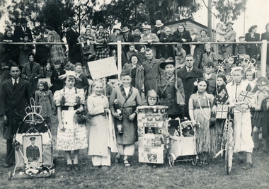
Photograph of Fancy-Dressed Children after WWI, Post-WWI
... . Possible the old Ringwood sports ground in Ringwood Street. Some... the old Ringwood sports ground in Ringwood Street. Some children ...Photograph of Fancy-Dressed Children after WWI celebrating the end and victory of World War One. A child is dressed in a Dutch dress, others in a dressing gown, grass skirt, a soldier with gun. The parents and other adults are in the background, some learning on the fence. There is a building the top right corner. Possible the old Ringwood sports ground in Ringwood Street. Some children have displays with "Victory" on them. Another has the British and Australian flags. -
 Vision Australia
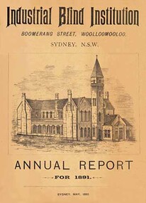
Text, Sydney Industrial Blind Institution annual reports 1879-1898, 1879-1898
... commenced of a two storey sandstone in Boomerang Street. Some... of people who were blind. A site near William Street was agreed upon ...In 1875 John William Wood left a legacy of 5000 pounds for a building to be erected for the benefit of people who were blind. A site near William Street was agreed upon, and building commenced of a two storey sandstone in Boomerang Street. Some months after its completion, a public meeting was held to inaugurate the Sydney Industrial Blind Institution, outline its rules and regulations and elect a board of management. To publicise it's work and gain donor support, the SIBI produced an annual report outlining the finances, facilities and programs offered.1 volume, illustrationssydney industrial blind institution -
Glen Eira Historical Society
Document - REGENT STREET, 73, ELSTERNWICK
... of occupiers at 73 Regent Street, Elsternwick, with some history... at 73 Regent Street, Elsternwick, with some history ...Two items about this property 1/typed copy of a list of occupiers at 73 Regent Street, Elsternwick, with some history of the street name; possibly was Ebden Street. Accompanying are handwritten working notes listing residents 1888 – 1974 2/handwritten file note of research from 1903 Sands and McDougall Directory indicating that Regent Street was previously Ebden Street; by GEHS volunteer Anne Kilpatrick.regent street, elsternwick, wigley arthur l., elston emma, o’brien william, mcconchie robert w., arnott john, davis george, payne charles, arnott arthur j., stewart peter, hart herbert d., clark george, martel kath, mcdevitt charles, mcmurrich r.t., wollaston m.f. mrs, mcinerney d.o., breen g.p. mrs, brown w.l., cox w.h., bullock hilary, landells rosalind, ebden street, ebden charles hotson